Friday, 19 August 2022

Montreal Street Underpass

I'm not sure of the correct nomenclature, but most references to this nifty bit of engineering are titled as above. Perhaps it's a subway or something else. Anyway, vehicles are passing under the Canadian National Kingston Subdivision Montreal-Toronto mainline, as well as a couple of lead tracks, near the switch to the waterfront Hanley Spur just east of the Outer Station. Fellow modeller Mike Hamer of Ottawa shared one of his father's pictures of Kingston. It shows a CN freight heading east over a car speeding north on Montreal Street, and was taken in 1951 (below). I'm not sure of the identity of that building at far right beyond the pole line. It may have been a sectionman's house. The second (slab-side) hopper would have been new, built by Canadian Car & Foundry in 1951:
You'd never know there was anything under the tracks in this photo, published to Vintage Kingston on Facebook, captioned 1956. It shows what appears to be a CNR U-2-a 6100-series Northern working hard to lift an eastbound passenger train out of the station and over the underpass. The rowhouses are visible at right, and there appears to be some graffiti written on the bridge.
Improvements were being made to the Montreal Street and Elliott Avenue intersection in July, 1966 (as shown in this Whig photo - top). The north side of the subway was being widened, though there was not much that could be done to improve visibility under the tracks themselves. A CN westbound freight train and the 'Grand Trunk Terrace' rowhouses on Cassidy Street are visible at centre. 

A 1966 aerial view (below) in which landmarks are the sectionhouse near top right, the Hanley Spur lead witih switch to the 'Chown' warehouse at far right, Cassidy Street rowhouses at left, and the sweeping 'S'-curve of Montreal Street at centre:

CN tracks seemed to pass over Montreal Street. More correctly, Montreal Street passed under the tracks, just beyond CN’s Outer Station.  In a February, 1970 Whig article, it was called, "a scruffy, square hole in the embankment over which Canadian National propels its sleek, up-to-date trains", noting there had been very few accidents because drivers were forced to slow down to about 10 mph to have any hopes of negotiating it safely! These March, 1966 Whig photos show the results of flooding, typical during heavy rainfall or snowmelt, as well as the narrow width and restricted height of the underpass!
Four tracks rested above on a 55 foot-wide bridge spanning Montreal Street’s not-quite-two-lanes. In fact, the street was 30 feet wide, the vertical height beneath the bridge 13 feet. Made of steel girders riveted together, open spaces between the girders were concrete-filled, all waterproofed by asphalt overlaid by roofing felt and tar. The underpass/subway became the city’s responsibility after annexation from Kingston Township in 1952. Another Whig photo from February 9, 1970 shows a reporter standing underneath, as two trucks pass through (Queen's University Archives, Whig-Standard Fonds, V142.7-215):
A transport truck was wedged underneath on October 29, 1969 as this Whig photo shows (Queen's University Archives, Whig-Standard Fonds, V142.7-126). Only deflation of the truck's tires could free it.
The crew of 3119, a CN RS-18 working the yard as a local roadswitcher, perhaps gloats at the competition's bad luck:
A screenshot from the 1970 short film 'Dear Landlord' shows this tribute to a local biker gang, graffiti'd onto the north side of the underpass span (below). Interestingly, the Hanley Spur is visible in the background, with a snippet of Montreal Street visible at bottom centre:
To show how seamlessly the underpass blended into the station scene, here's an L.C. Gagnon view of a westbound CN passenger train passing over it in August, 1970. The railings above the underpass are just visible to the right of the insulbrick section house, just to the right of the approaching train:              
As the city grew, suggested improvements were made: a realignment of the roadway, moving the south wall back 12 feet to provide two full traffic lanes plus a sidewalk. With the construction of a new CN passenger station on Counter Street near outer Princess Street, the CN mainline curve was realigned; the previous alignment over Montreal Street made obsolete. Access to the Hanley Spur was maintained from Elliott Avenue, with the former mainline tracks in front of the station stub-ended.

The bridge was removed by CN crews beginning on March 3, 1976. To facilitate its removal, a detour was built using dumptruck loads of gravel. The detour route began in the station parking lot, headed over the tracks just east of the station buildings, reached Cassidy Street thence regaining Montreal Street. Removal was completed by March 15, 1976. In his excellent book At the Bend in the Road Kingston, Gordon Smithson captured the removal on film for posterity.

A wider 1966 aerial view shows the juxtaposition of the underpass with the CN Outer Station at bottom, with the Frontenac Floor & Wall Tile plant across the station yard:
This is always a head-scratcher for me, both aerially and on the ground...trying to place the location of the former underpass on today's Montreal Street. Krown Rust Control is a good landmark, (paved lot at bottom left of the 2017 photo) and still there today. The Grand Trunk Terrace rowhouses are now along Montreal Street, no longer Cassidy Street. The 'Chown' warehouse is now part of the Village on the River apartment complex, visible as brown roof at top right of 2017 photo, with the Hanley Spur right-of-way still somewhat visible!
Though many bemoan the sorry state of the Outer Station, I don't think too many will mourn the removal of the Montreal Street underpass!

Wednesday, 17 August 2022

Limestone Rock Cut Scenery

It's not just limestone here and vegetation over there. This view taken from the Montreal Street overpass shows that vegetation eventually finds its way into limestone. Whether it's from soil being washing downwards by water into crevasses, seeds finding fissures, gravity taking branches and weeds down, or water working its wonders, the photo makes it clear that there is a juxtaposition between grey and green.

Perhaps a freshly drilled rock cut would be the only pure rock face. Otherwise, grab some green. I just may use this photo as prototype modelling inspiration! 
 

Sunday, 14 August 2022

LaSalle Causeway - Then and Now

A recent walk onto the LaSalle Causeway reminded me of some archival views that I've seen. In this post, I attempt (as closely as possible, realizing that the westernmost span is no longer in place) to match current and past views. Definitely an important part of Kingston's waterfront, the causeway was a portal for vessel docking as well as letting vessels into the Inner Harbour.
1929 Richardson grain elevator and Canada Steamship Lines canallers

Hall Corporation ships tied up for the winter see spring in March, 1953

Another view from March, 1953 -  with work on the bridge certainly nothing new!

Walk for OXFAM - September, 1967

Heading In - tanker Imperial Cornwall - April, 1961  (Don McQueen photo)


Heading In - HMCS Inch Arran scrap tow behind tug Flo Cooper July, 1969

(Black & white and archival photos in this post from Queen's University Archives unless otherwise credited)

Saturday, 13 August 2022

Montreal Street Remodelled

After researching the Davis Tannery, I decided it deserved a place on my HO scale Hanley Spur layout, complete with CN spur. But where? The only available real estate seemed to be where Montreal Street had previously been modelled. That streetscape included three buildings and a two-lane street leading to Rideau Street. It was perhaps scenic but added no operational possibilities. After removing the scene, I relocated trackage and added four new scenic elements, structures or operations.

At top left is the new Cohen scrapyard, served by CP. At bottom left is the Davis Tannery, served by CN as is the relocated CN Express building. In between is an ex-industry currently inhabited by some homeless folks. At bottom right is the relocated CN telegraph repeater building, and the newly-expanded Outer Station:
This black and white version shows elements of the former scene. The former CN lead is represented by the red line, with a spur serving CN Express. The street scene and structures lined the layout edge (above). Below is the best representation I found showing the former scene. The CN eight-hatch reefer is spotted at CN express, with the streetscape in the foreground. In 2020, there were still houses located here as placeholders.
A good magician doesn't reveal his tricks, and these overhead views make my layout make my layout look much smaller than low-angle trackside scenes. But I'm happy with the new space allocation, so why not?
Now to validate the new operational possibilities. Certainly the Outer Station has more room to breathe! And there is still a little four-inch square spot just past the repeater building that could be...something.

Friday, 12 August 2022

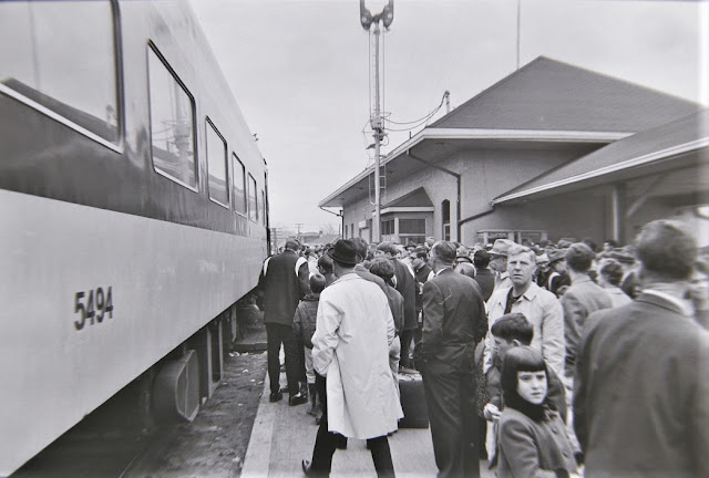
Outer Station Platform Scenes

Kingston's Outer Station, 1900. Eastbound Grand Trunk Railway passenger train. (Need I say...not my photo? Online auction site photo.) The curve and the photo angle show the sharp curve on which the 1855 station site was located. This is a super-archival photo, but I would also like to share more recent, perhaps more relatable more recent images in this post.
The CN Outer Station on Montreal Street was often a busy place. This post shows some of those platform scenes. December 29, 1966 (top photo). In 1948, reserve sailors from HMCS Cataraqui with their transport in the parking lot:


Girl Guides leave on a morning Railiner, August 28, 1966 to the Canadian National Exhibition in Toronto:
Twenty-four Grade 11's departing for a week-long Adventure in Learning in Nova Scotia, sponsored by the Canadian Centennial Commission on July 27 1966
As part of the same federal-provincial youth travel program, 24 high school students form Saskatoon arriving at Outer Station August 25, 1966
Midget hockey players from the Centennial tournament depart Kingston on April 3, 1967.
A westbound train was two cars short, so players had to scramble for seats during a 30-minute delay after bidding their local billets farewell:
The Outer Station platform saw many departures and arrivals of troops during the Korean Conflict. This photo was taken in May, 1952
KCVI Army Cadets about to head to six weeks of summer cadet camp at Ipperwash, ON on June 28, 1952:
On November 10, 1959 Eskimos arrive for engineering training at CFB Kingston:

(Photos in this post from Queen's University Archives except for top photo)
 

Third Crossing West Shore - Then and Now

As the city's Third Crossing across the Great Cataraqui River comes close to completion, the project's final steps are being publicized. The above image shows the current drone view of Montreal Street, with the new John Counter Boulevard cutting across the aerial view and leading to the west bridge approaches. Having just traversed this area on foot, I enjoyed the challenge of marking approximately where the CN Kingston Subdivision mainline (yellow dots) and Hanley Spur (red dots) once ran. The 1974 mainline realignment between Montreal and Division Streets is just visible at the extreme right. 

Contrast that with the sparsely-populated circa 1948 aerial view by George Lilley (Queen's University Archives photo) that also shows Elliott Avenue cutting across the former Outer Station alignment, with Montreal Street heading to the left and the Hanley Spur just east of it near the river. The city limits end just inside the curve, prior to four waves of annexation of the former Kingston Township.
That CN mainline curve was sharp and speed-limiting. Those seeing the current view and trying to imagine what it used to look like face a real challenge!

Thursday, 11 August 2022

Outer Station Enhancements

Re-jigging the Montreal Street segment of my Hanley Spur turned streetscape into more opportunity to add structures and spurs. One of these was enhancements to the Outer Station. Confined to the highly-recognizable 1855 limestone Grand Trunk station, I could only represent the breezeway and 1895 brick station minimally (below). I made a paper cutout of the available space (top photo) and began deciding how much of the other two parts of the station I could represent.
Having mapped out the space available, I used an existing structure, formerly part of the Rutland, VT Howe Scale complex. It was too high, too wide and had no windows. I rectified all that, with prototype photos at hand:
Originally red brick, modernization took placei n the 1960's and the wartime breezeway was an essential part of handling increased passenger loads in all weather. I used Tupperware to gauge the height of all three structures:
I added roofing to the 1895 station - largely Cox Big Pine Lumber Co. shed roofs. The prototype was shingled, but until I get adequate shingle paper, this black-is-the-new-yellow material will work. Working in the sunroom with beverages at hand:
The 1895 station is done, the breezeway is not done.Test-fit on the layout (below). After assessing this photo, the angle of its roof is wrong, therefore the legs and roof (well, that's almost the whole thing!) had to be redone.
Breezeway improved. Signage added, along with train order signal, smoke jack, downspouts and repainting of doors and windows. I realized by accident that if some grey paint was scraped off, the underlying brick finish would show through. Outdoor photography at sunset:
There were two prototype phone booths on the far side of the breezeway nearest the 1895 station. Why model one if it will be unseen? So I did model one, and placed it more prominently! Now, to pave the parking lot and put up this paradise!