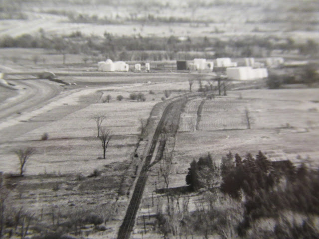
Actually, before there was a Highway 401. The building of a [bridge] above the CP for Highway 401 was authorized in 1955, with official approval to operate given in 1958. These undated City of Kingston archives aerial photos (Queen's University Archives, City of Kingston Planning Department, V123.1-12) showing Highway 401 construction at Highway 38 are remarkable. Not only because they seem to show the 401 ending and exiting to Highway 38 at the time, but also because I picked out an unknown siding on the straightaway of track leading toward the Sydenham Road bulk fuel tank farm in the distance, built circa 1953. One end of the siding is just visible at bottom of this cropped version:
The siding is on the south side of the CP Kingston Subdivision, east of the culvert through which the CP passes under the highway, and parallel to the current 401:
A 1940 topographical map view shows the siding at this location (red arrow). In a 1950 CP employees' timetable, a 10-car capacity siding at Cataraqui flagstop was shown six miles north of Kingston, and four miles south of Glenvale. Knight's Siding is shown in a 1909 K&P timetable. The Glenvale siding was 14 cars or 1083 feet. On Colin Churcher's CP Kingston Subdivision page, Knight's Siding (Mi 97.64) is shown east of Highway 401 (Mi 97.08), and west of Sydenham Road (Mi 98.33). This differs from K&P Trail signage that shows Knight's Siding east of Sydenham Road.
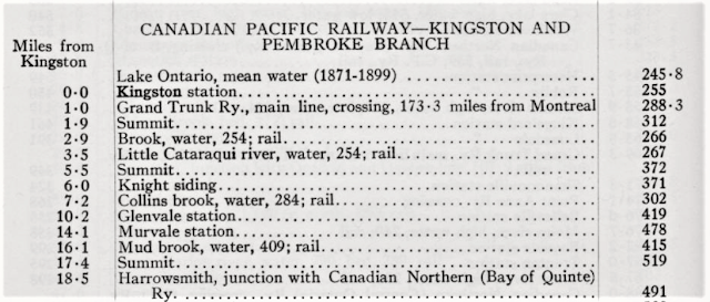
Given the winding grade up Gibson's Hill, which can be seen crossing contour lines on the topographic map, I've often wondered if the original Kingston & Pembroke line was built with sidings for doubling trains up the grade. This one located south of the grade, and at Glenvale north of the grade, if needed. Another data point - my brother shared a scan of a table from the 1915 Altitudes of Canada (below). The southernmost segment of the Kingston & Pembroke 'Branch' of the CPR, with the Kingston station on Ontario street, Grand Trunk Ry. still reflecting the diamond crossing,
Knight siding was named for Stephen and Archibald Knight, landowners. Archibald was born at Cataraqui in 1843 and farmed two miles north of there for 50 years, before dying in 1918. A 1953 image from the City of Kingston map page shows the line and the siding, before heading from the OIL through the circle then north to McIvor Road.
Close-up inside the circle, showing the farm road crossing just west of the siding:
Thanks to David Gagnon for the scan above, and the topographic map link.


Perhaps the folks in charge of the signage should be sent notice of your puzzlement.
ReplyDeleteThanks, A. - that just might happen...
ReplyDeleteEric