Tuesday 13 December 2022

Reverse Engineering: Hanley Spur Trackplan

Four scant years ago, I huddled with some local source material and designed the trackplan for my layout. How did we get here from there? A message from fellow blogger Chris Mears really got me searching back 4 years, actually back to 1970...how did I come up with this trackplan? What were the signature scenes I had to include, and how did I spaghetti-bowl all these spurs in there? There are actually more industry spurs now than in the 2018 trackplan (top photo). Let's flip back through the serendipitous synoptic scribbler to see...
There I was, enjoying a million-dollar view - sitting on a park bench at Lake Ontario Park, overlooking Kingston's Elevator Bay and the lake. At the top of a breeze-blessed hill, I doodled on a notebook page with the lofty-sounding label, 'The Hanley Spur - Imagined -' as I started to sketch an imagining of a someday model railway layout based on Kingston's waterfront industrial trackage. It was a sunny Sunday afternoon in October, 2018. Just two days earlier, in the same notebook, I was still sketching trackplan and structure additions to my Vermont prototype iteration of the layout!

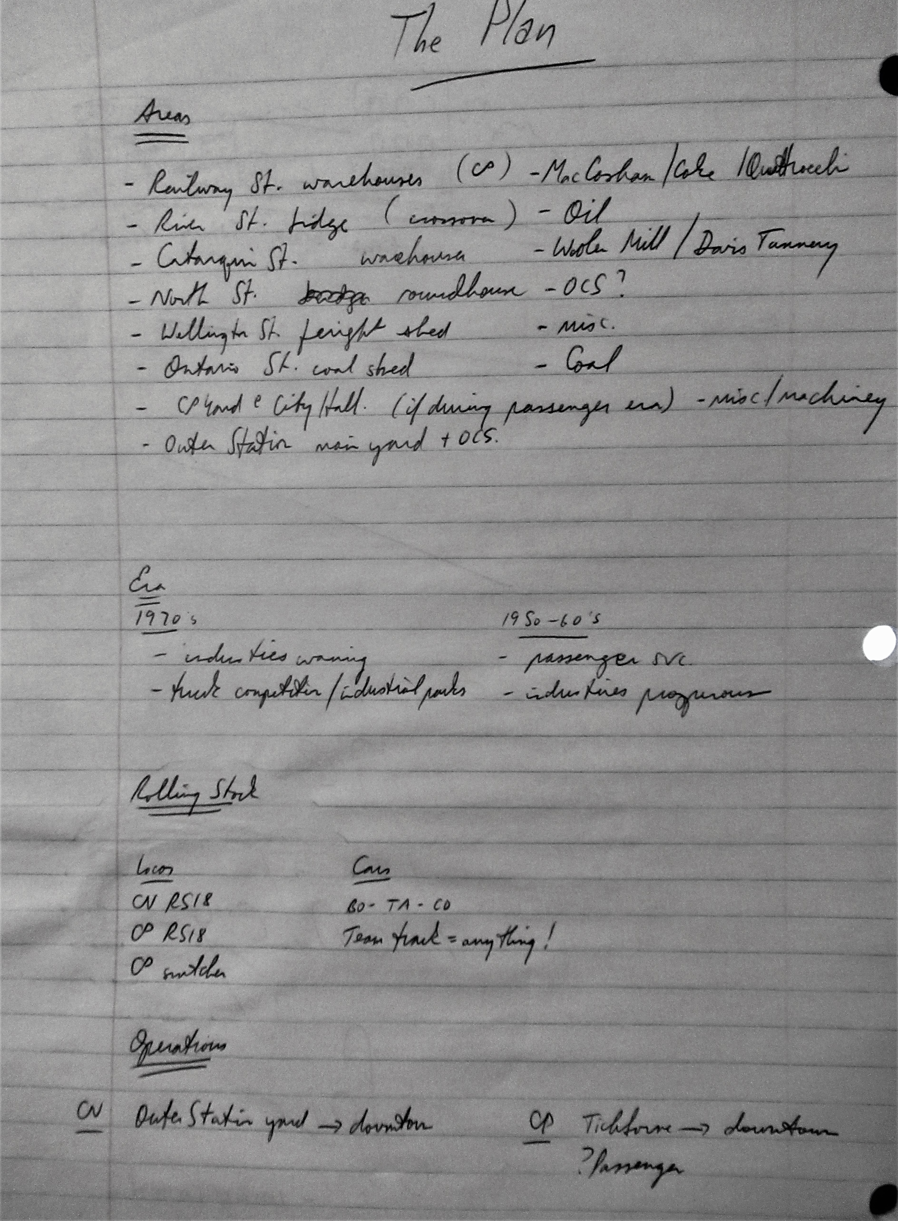
Undaunted, the first challenge was turning the schematic sketch into a trackplan. In my modest 10x11-foot space, I would need to thread CN and CP lines between the downtown core and the Cataraqui River, incorporating signature scenes along the way. To paraphrase Bob Seger, 'What to leave in, what to leave out'? With the grandiose title, The Plan, I scribbled down the Hanley Spur's raison d'etre in 14 Areas, two potential Eras, Locos and Cars, and CN and CP Operations:
A 'From the Air' sketch was fun to imagine, sitting lakeside. It included major streets with CN and CP tracks and the limitations of the 2-mile line I'd selectively selected from memory:
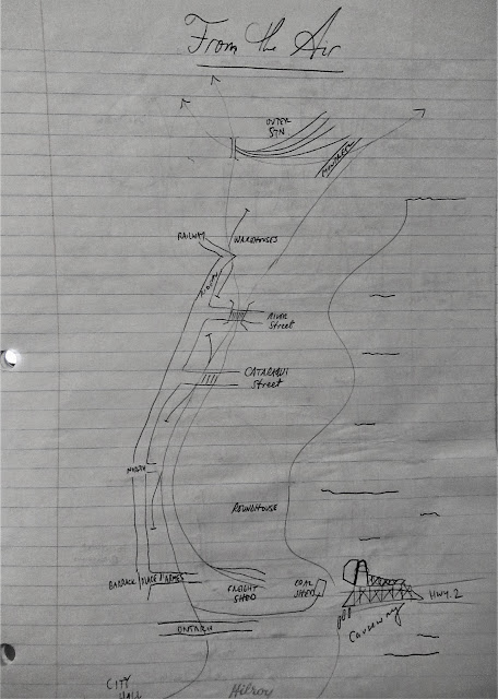
One of the more challenging elements of this Hanley Spur iteration would be including and inter-weaving the nearly-parallel CN and CP lines, where each line originated, and how to incorporate elements of the existing Vermont trackplan that were fun to effectively operate. Two industries were jointly-served by CN and CP. Yikes! Run-around tracks on CN and CP would be important to facilitate switching. I really liked the run-around tracks I'd already had in Vermont -  two would now be CN, and one CP. I also wanted to maintain a continuous-run option as shown in this very first draft schematic:
Inevitably, day-dreaming meets the real world. I hesitate to over-use Givens and Druthers, the planning terms often attributed to dean of trackplans, the late John Armstrong. But those two words really work and I actually used them to list industries I wanted to incorporate! I needed to make the tough choices - which industries to cut, and where to emplace the ones I'd be keeping. I was already planning operations, dividing switching runs to serve groups of industries.
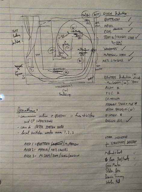
With a very 'tracky' spaghetti-bowl design, it's hard to draw in or remove tracks. Another revision was the inevitable next step! CP was posing a challenge, and where to include the warehouses that CP served?
I also needed to keep in mind the 'anatomically-correct' order of industries that trains would encounter while working the spurs northward and southward. Maybe if I drew schematics of the CN and CP lines from north to south:
Two more revisions. I toyed with moving the CP warehouses, the jointly-served industries, and the CN Queens interchange. Even the end-of-track in the centre peninsula was going to be challenging.
There wasn't going to be room for the CP warehouses on the aisle. Moving them to the wall-side of the layout was a way of aligning CP on the outside and CN on the inside:
I was developing switching runs in the margin (above). Then, when the Sharpie marker comes out, you know you're getting near the end of the planning process. This is the 'final' trackplan shown in the top photo. Of course, it's never final. The industries around Cataraqui Street were still not where they'd end up!
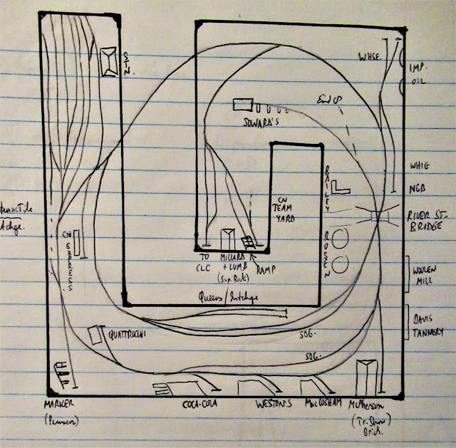
The last bit of trackplanning involved fixing lots of switchbacks in the 'End of the Line' CN freight shed area. The Sharpie plan exists today. I've added a few tracks (of course!). This minimalist movement of today's industrial switching layout planning does not mesh well with my industrial-switching influence from decades ago.

The Davis Tannery, Frontenac Floor & Wall Tile, Queen City Oil, Cohen scrap yard, Woolen Mill, and a single CP spur serving three industries - Shell Oil, Canadian Dredge & Dock and Anglin lumber - have been added since. I also finessed the locations of the CN freight shed and Whig/NGB spurs.

This retrospective view of the trackplanning process is a useful record of how the current Hanley Spur layout came to be. What's called 'reverse-engineering' these days - a nice way of describing my lack of in-progress photos and account of what-happened-way-back-when. Now, was that 2018 or 1970?

Friday 9 December 2022

Index of Posts

Blogger's software does not make it easy to find a particular post in a blog. Here's a list of my most useful posts, divided into Prototype, Model and Other categories: Newest posts in each section are at top, and the index is current as of December 3, 2023 - back to November 3, 2018.

History of the Prototype

Model: My Hanley Spur Layout

Updates and Other

Producing this index of posts was inspired by Stephen Gardiner's well-organized blog. I trust you'll find it ueful if researching a prototype location, industry, event or era. The Model section lists posts in which I model a building, location or facet of operation. The Update section includes ancillary posts - research, walking tours or other resources.

Thursday 8 December 2022

Well-Housed on Wellington Street - Again


Just like last year, I found myself in our local Dollar Tree in front of a shelf-full of little Christmas-tree houses. And just like 2021, I wondered if I could make a silk purse out of a sow's ear, at least as far as these little plastic structures were concerned. Challenge accepted!
The very first item of business was removing the bell-tower from atop the fire station (left), while I'd initially thought the yellow cafe might end up being a house. I decided on a corner store. I decided not to alter their original format, at least for now.
Cruising around the Swamp Ward on Googlemaps for inspiration, I decided the fire-station would get a limestone treatment, and the cafe would get a reddish-brown with white trim treatment. This year's buildings didn't have big snowbanks at the base, but they did have a nice foundation I decided to keep and paint concrete-coloured.

Unlike last year, these structures each had a three batteries and a bulb. I salvaged the batteries and started some initial coats (above) of paint. I Sharpied the yellow windows, greyed and blacked the roofs, and definitely toned down that window shade! The store windows got white and grey details, and the pilasters got weathered white. I painted the chimney bricks and mortar:
I used a printed brick building front on the store's lower storey (rear view), and limestone paper foundation. It had two good sides to which I could add signage and place on a corner lot. A couple of greys on the 'fire-station' led me to realize it would be an old-timey garage/ dealership.
The final views, with rust over the garage door, toned-down window frames on the 'garage'. I made the store into Cochrane's, a Swamp Ward fixture at Bay and Bagot Streets. I added Pepsi and other signage, lettered the main sign, papered over the window shade, added a fruit stand, and didn't stop the scrapes on the roof paint. Those blue shingles underneath sure were bright!
So that's four dollar-store houses on my one residential layout street. I haven't decided on a final arrangement/rotation for them. (Do I have to?) If I do, I will definitely be adding some rear annexes, fire escapes, and other structural extensions. Just like the real thing!

Monday 5 December 2022

K-D Manufacturing - History


K-D Manufacturing was located cheek-by-jowl along Montreal Street just north of Railway Street. (That house is 13 feet south of K-D's property line.) Producing picture frames and other wood and decorative products on the site for over 70 years, its sprawling, rambling operation was a fixture in that part of the city. This 1984 satellite view shows (R)ailway Street, (M)ontreal Street and (Q)uattrocchi's with K-D's multiple long Quonset hut manufacturing buildings, with the 'M'  just in front of the office pictured in the top photo:

1937 city directory ad (above).
1921 Whig article and ad, published one year after the founding of the factory by Howard Kelly and a Mr Driver, the latter leaving the business shortly thereafter.
The plant site was a frequent fire-call destination, often due to sawdust piles and kids playing with matches! A major fire made the Ottawa Citizen on December 19, 1945:
Two aerial views of the K-D Property:
Lumber piles around the K-D buildings in 1948 (above - Queen's University Archives, George Lilley Aerial Photographs V25.6-9-23). 

This April 21, 1951 view interestingly shows the old (crossing centre) and new (left) CP alignments. (Below - Queen's University Archives, George Lilley Aerial Photographs V25.6-5-30):
High employment at the plant was 100 workers. 1955 Whig ad and article:

A shop floor worker in 1983 could expect to make $7.55 hourly. The average length of service for the 60 workers was 20 years. More than two million frames were produced at the plant yearly. Howard Kelly, grandson of one of the company's founders, served as Vice-President for 15 years becoming President in late-1988 when his father, President W.A. Kelly entered semi-retirement.

In 1989, the plant's potential move to Watertown was made public. A Watertown want ad for a shop foreman didn't help! The new 50,000 sq,ft., $2.4 million plant was aided by a New York regional economic development loan of $400,000. Neither plant manager Peter Schmitt nor President Howard Kelly would comment on the future of the Kingston plant. The new plant would employ 25, the Kingston plant employment was dropping steadily from 50 toward 25.

Howard Kelly was the third-generation owner of the operation, living in Watertown at the time. The last 20 Kingston employees were laid off as production wound down in June-July1990, the plant closed due to lack of profitability and outdated 1940's equipment. Free-trade and cheaper non-union labout definitely contributed. A contract had just been signed between the plant's union, the Carpenters and Joiners of America and management.

A 1997 fire ripped through the 60,000 square feet of manufacturing space.

Saturday 3 December 2022

Modelling K-D Manufacturing

Located at 670 Montreal Street, K-D was a local manufacturer of picture frames, as well as mirrors, mouldings, and pictures sold nationwide. Its sprawling site is still a brownfield, but sited in the corner of my Hanley Spur layout, it's a signature structure, albeit not rail-served. I picked up the main structure 'on spec' at the Associated Railroaders of Kingston Rail Fair in November. It was not real fair, because I didn't have my reading glasses and grabbed it, believing the price was $5. Bargain! Paying in better lighting, I realized the sticker said $15! Oh well, still a bargain and I didn't have to build it. Whoever did has done a nice job! It was the Walthers Henry Road's First Factory:
A view of the Montreal Street-facing K-D office, showing its unique hand-painted lettering, the smaller lines of which I can't make out from this photo found online:

At first I thought of hand-lettering the front of the building, and I might still. But for now, Google helped me find "Manufacturing Co. Limited" images, to which I added K-D and smaller line below:
With the sign printed, I didn't add much to the main structure, but I wanted to extend the building and decrease its size leading into the corner, to add perspective. The wall of a station kit from the parts drawer would do:
I glued on the painted addition, preparing to add an arched Quonset roof:
Then it was time to give the whole structure a black hobby-paint wash:
Finished with signage and roof vents, pending final scenicking:
The prototype right up to Montreal Street. Interspersed with residences, surrounded by trees and the whole sprawling operation.
A city directory 1937 cover ad:
Sold in local stores, I found a K-D frame in the layout room! The operation later moved to the U.S.!

Muddle in the Middle of Montreal Street - Solved!

In this post from 2020, I shared my muddle about what was going on, or not going on, in the middle of Montreal Street. More accurately, a distant corner of the layout that was largely unreachable, and had become a laundry basket in which elements were thrown, but not organized. Elements of Division, Rideau, Railway and Montreal Streets. Fortunately, I'm now able to go back and resolve some of these issues, and I consider this muddle now solved.

There's a lot going on in a 1964 aerial photo of the area in question, to which I've added some labelling (top photo - Queen's University Archives, Kingston Whig-Standard Fonds, V142.1-60) shows the CP line cutting across horizontally, CN's Hanley Spur diagonally at bottom, then (C)ohen's scrap yard, (M)acCosham and (G)amble-Robinson on (R)ailway Street meeting (M)ontreal Street on which we find (Q)uattrocchi's and (K-D) Manufacturing with its multiple Quonset-style buildings.

Something had to stay, something had to go. I've successfully sited Frontenac Floor & Wall Tile, Quattrocchi's and Cohen's in this corner (below). Unfortunately, Gus Marker Cement (now The Big White Space) had to go. It was a good space filler, but was located on geographically-distant Division Street on the prototype. I was spotting a lot of modern Center-Flow covered hoppers there - a car type I have a lot of, and really like - but that are not really prototypical. 
All was not lost, because I was adding two-plus new businesses. And doing some road work, that perpetual Kingston activity! I'd always wondered why I'd found references to several car spots, especially on the CP, in this area. The two oval areas in the top photo show why. Some transitory businesses were located here, including team track unloading directly from rail-to-truck. So, I repurposed the Gus Marker spur, now calling it Quintane Gas. It's  neat prototype name, though I've found little prototype information on the business so far. Their propane tank is visible inside the right-hand oval, with a tank car spotted there. Two CP spurs (FF&WT joint with CN) and the lead are at rear, with CN's Hanley Spur passing the tannery in the foreground:
I've connected this layout-edge road over the tracks, and it now extends to the corner. It's painted foamcore, screwed down with Robertson screws and joined by modelling clay:
The road over the last two CP crossings beyond Quattrocchi's, with FF&WT at right. Now, to build the level crossings. The Big White Space awaited. The keystone of this corner was the new K-D Manufacturing structure I'd just completed:
More on the K-D build in the next post. Once I had the dimensions of the main building, I was able to start scenicking the corner. That included trying a backdrop of the actual Montreal Street, blending the road colour lighter into the corner. That large fertilizer plant (!) in the adjoining backdrop may be covered up by trees or other buildings.
The term 'selective compression' is often used by model railroaders. It's the process by which elements of large buildings are shrunk to fit available space. I prefer my own term, 'selective selectivism'. That's my process by which I incorporate elements of the prototype, resulting in a signature structure that approximates, but may not be a scale model of the prototype. With space always a challenge, there are next to no Hanley Spur buildings that I can model in scale! Now, in this corner....

Saturday 19 November 2022

CP Siding South of Highway 401

Actually, before there was a Highway 401. The building of a [bridge] above the CP for Highway 401 was authorized in 1955, with official approval to operate given in 1958. These undated City of Kingston archives aerial photos (Queen's University Archives, City of Kingston Planning Department, V123.1-12) showing Highway 401 construction at Highway 38 are remarkable. Not only because they seem to show the 401 ending and exiting to Highway 38 at the time, but also because I picked out an unknown siding on the straightaway of track leading toward the Sydenham Road bulk fuel tank farm in the distance, built circa 1953. One end of the siding is just visible at bottom of this cropped version:
The siding is on the south side of the CP Kingston Subdivision, east of the culvert through which the CP passes under the highway, and parallel to the current 401:
A 1940 topographical map view shows the siding at this location (red arrow). In a 1950 CP employees' timetable, a 10-car capacity siding at Cataraqui flagstop was shown six miles north of Kingston, and four miles south of Glenvale. Knight's Siding is shown in a 1909 K&P timetable. The Glenvale siding was 14 cars or 1083 feet. On Colin Churcher's CP Kingston Subdivision page, Knight's Siding (Mi 97.64) is shown east of Highway 401 (Mi 97.08), and west of Sydenham Road (Mi 98.33).  This differs from K&P Trail signage that shows Knight's Siding east of Sydenham Road.
Given the winding grade up Gibson's Hill, which can be seen crossing contour lines on the topographic map, I've often wondered if the original Kingston & Pembroke line was built with sidings for doubling trains up the grade. This one located south of the grade, and at Glenvale north of the grade, if needed. Another data point - my brother shared a scan of a table from the 1915 Altitudes of Canada (below). The southernmost segment of the Kingston & Pembroke 'Branch' of the CPR, with the Kingston station on Ontario street, Grand Trunk Ry. still reflecting the diamond crossing,
Knight siding was named for Stephen and Archibald Knight, landowners. Archibald was born at Cataraqui in 1843 and farmed two miles north of there for 50 years, before dying in 1918. A 1953 image from the City of Kingston map page shows the line and the siding, before heading from the OIL through the circle then north to McIvor Road.
Close-up inside the circle, showing the farm road crossing just west of the siding:

 Thanks to David Gagnon for the scan above, and the topographic map link.