Tuesday, 2 July 2024

Up, Down and Out: The LaSalle Causeway Bridge


The LaSalle Causeway bridge was a federal property that allowed marine access to Kingston's Inner Harbour from its Outer Harbour for 107 years. Put in place as part of a Foot of the Lakes terminal project, the bridge opens an average of 900 times per year. Due to undisclosed damage that occurred during a recent maintenance project, the bridge was condemned and demolished by Priestly Demolition Inc. The delays associated with analyzing the damage and formulating a plan caused consternation to remaining marine businesses in Kingston - MetalCraft Marine and local cruise lines. In the future, a temporary 'Bailey bridge' is expected to be in place this summer, with a more permanent link, of an unknown design, still allowing marine access to be constructed in future. 

The challenge of designing a bridge for this location is the lack of room for an eastward approach along Ontario Street/Highway 2, the need for mast-height boat access, and a setting challenged by nearby wetland preservation and historic harbour bottom contamination. Only the central of three original steel bridges remained in 2024. (Top photo - Queen's University Maps and Air Photo Collection, Rideau Air Photos 1950-55)

This bridge is a large and exceedingly rare example of a Strauss heel-trunnion bascule bridge in Canada. Famous engineer Joseph Strauss's single leaf heel-trunnion bridge was more common on railways, but is today rare anywhere in Canada, partially due to demolition. Compared to other Strauss heel-trunnion bascule bridges, Kingston's has a very unique appearance that makes the bridge unique. This is due to two factors. First, the rocking truss that holds the counterweight and rotates around the counterweight trunnion has more angles to it, and more diagonals extending from the counterweight trunnion that with most heel-trunnion bascule bridges. This gives this portion of the bridge a more curved appearance. Secondly, the top chord of the bascule leaf is not parallel to the bottom chord - the truss depth decreases as it extends away from the counterweight link. (Historic Bridges site)

George Lilley photo of west bridge, 1940 (above - Queen's University Archives)

Sitting in the middle of a causeway, the bridge is hard to ignore and is a recognizable landmark. Some alterations have been made to the bridge over the years. Some of the vertical members have what was likely originally v-lacing or lattice replaced with plate with circular holes in it. A historical photo of the bridge shows a highly ornamental bridge tender house next to the bridge at the level of the top chord. The house is no longer in place. The current bridge tender control house is located at ground level at the northwest quadrant around the bridge. Inside, it contains modernized operating control panels for the bridge. The concrete counterweight has had steel paneling added around it.

  • The 1829 “Penny Bridge,” a wooden toll bridge with a swing section to allow passage of marine  vessels. In May of 1911, The Cataraqui Bridge Co. had conveyed its dilapidated Penny Bridge to the city, who in turn ceded title to the Department of Public Works in June, 1912. Begun in 1826, Penny Bridge bridge shares were sold for $100 to raise the $24,000 needed for its construction. At 25 feet wide and 1,800 feet long, the bridge opened for traffic in 1829, charging a penny per pedestrian.
  • 1917: A single-leaf Strauss heel trunnion design of the Strauss Bascule Bridge Co. of Chicago was built by the Hamilton Bridge Co. “Trunnion” is a French word for “pivot point.” A trunnion bridge pivots like a see-saw around a central core. This is a key operational component of the bridge that requires regular scheduled overhauls to ensure ongoing operations.The original East Bridge and West Bridge were single-span through truss structures in 1917.
  • 1966: The Bascule Bridge operating mechanism was renewed, including a new operator’s cabin and control electronics.
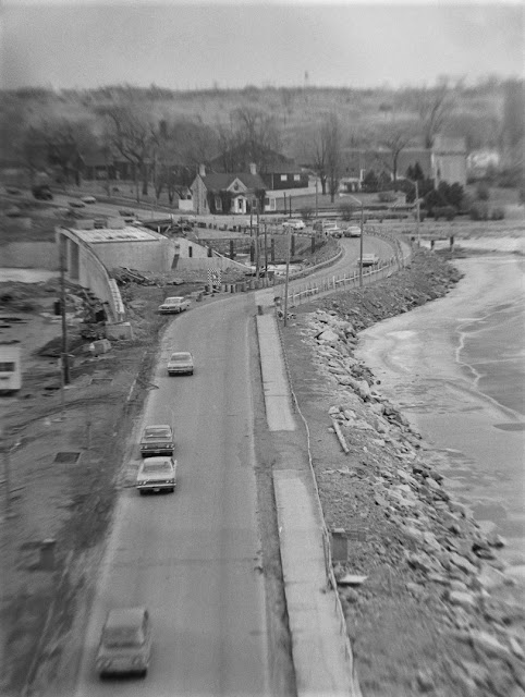
  • 1968-69: The East Bridge was replaced with a two-span pre-stressed concrete slab beam bridge  designed by C.C. Parker & Associates Ltd. Construction of the roadway bypass allowed the eastern span of the bridge to be raised to 13'6" to allow more vessels to bypass the main liftable span. The work was contracted to Master Craft Bridge and Engineering Construction (Ottawa) Limited. At the time, the causeway was handling 12,000 car trips per day, with numbers expected to increase to 25,000 by 1981 and a second bridge crossing of the river was already being called for. Before replacement, perhaps a good fishing spot (below - Queen's University Archives, Kingston Whig-Standard Fonds V142.3-160):
    Below-August 19, 1968(Queen's University Archives, Kingston Whig-Standard Fonds,V142.6.104)
    Below-March 25, 1969(Queen's University Archives, Kingston Whig-Standard Fonds,V142.6.288)
  • 1973: The Bascule Bridge floor beams were replaced with welded wide flange beams.
  • 1981: The Bascule Bridge floor system stringers were replaced, along with the timber sidewalk stringers and deck planks.
  • 1994: The West Bridge was replaced with a 2-span pre-stressed concrete box beam girder bridge.
  • 2001: Two buffers were added to the Bascule Bridge to reduce impact when the bridge lands.
  • 2004: A maintenance contract on the Bascule Bridge was completed to replace rivets in fatigue- prone members of the counterweight.
  • 2009-2013: The Bascule Bridge underwent a major rehabilitation, which included: removal of lead paint; structural repairs to deteriorating steel members (i.e. operating arm, bottom gusset plates, exterior splice plates in the bottom chord, etc.); reinforcing certain diagonal truss members; replacing timber sidewalk stringers and deck planks; installation of new pedestrian railing; replacing traffic barrier; and replacing wood stairway treads with steel treads; installation of a new steel counterweight for balancing the bridge.
  • 2017: Replacement of the buffers; detailed inspection and repair options report for the steel deck grating; repairs to the span locks and bottom chords of the leaf truss; upgrades to the motor drive and motor control upgrade; rehabilitation of the guide assemblies.
  • 2020: Mechanical systems were repaired to address the systems’ deficiencies that impacted operations.
  • 2021: Structural steel was repaired to address fatigue issues in the structural truss.
  • 2022: Concrete repairs were completed to address deficiencies on the road and critical structural items for the health and safety of the public.
  • 2023 : Bridge deck replacement, trunnion steel rehabilitation and counterweight rehabilitation were underway.
  • 2024: The trunnion was damaged during the re- construction on Saturday, March 30 at 5 p.m. The steel is believed to have become too fatigued to continue with load bearing pressures.
        A capsule history and photo (above) posted to social media shows the bent member. A complete engineering study of the bridge from 2017 included this graphic of the bridge's design:
        A news clipping from the official opening of the bridge - opened April 16, 1917 (Daily British Whig clipping, published April 19, 1917)...

        ...and photos published August, 1917:
        Motorboats under the raised bridge, July 2, 1964 (Queen's University Archives, Kingston Whig-Standard Fonds, V142.1.161):
        Harbour view March 30, 1967 (below - Queen's University Archives, Kingston Whig-Standard Fonds, V142.3.121)
        HMCS Inch Arran is towed into the Inner Harbour October 11, 1966, (below - Queen's University Archives, Kingston Whig-Standard Fonds V142.3.266)
        A view from the dome of Kingston City Hall in 1973, tug and barge entering the Inner Harbour past an idle ferry and laid-up lakers. (Queen's University Archives, Arlie Robb Fonds, Box 7):

        Other posts involving the causeway:

        Belle Park from the Air 1924-2024

        Belle Park has seen quite a transformation over the past one hundred years. On June 26, the video premiere of Belle Park from the Air 1924-2024 took place at the Broom Factory on nearby Rideau Street. Made by Dorit Naaman, Francine Berish, Laura Murray and Matt Rogalsky, the short film traces the site through the progression of wetland-landfill (1952-1974)-golf course (1978-2017)-park.

        From a bird's eye view, aerial photos from the national and provincial air photo libraries are synchronized with each other over time, and an intriguing sound track. The Belle Park Project's rich website will lead viewers to the from the air page and the film on YouTube.

        Tuesday, 11 June 2024

        Wandering Wellington Street Once Again


        Yesterday, during another medical appointment drop-off, I had extra time to drive around downtown to check out various industrial waterfront sites of interest. This pop-up post contains my photographic proceeds. Looking very much like a chalet in the Alps, albeit in the shadow of Rideaucrest, the Doornekamp Queen City Oil Company  is slowly progressing. Look at the pitch on that new roof (top photo).
        I had never snapped this mural on the south side of the Woolen Mill. Nearby farther south is a fenced off area for a proposed residential development, labelled in this Googlemaps image as Molly Brant Point. Formerly the site of oil and coal depots, and like many locations along Kingston's former industrial waterfront, I'm sure remediation will result:
        Inner Harbour view towards the doomed LaSalle Causeway bridge, taken at the Woolen Mill parking lot. A big road crane has arrived to begin disassembly. Many Kingstonians are getting positively sentimental about this soon-to-disappear green metal monster!

        These former PUC buildings, on Queen Street, hemmed in by new developments, will probably soon also be toast:
        The Merchant:
        Former joint trackage location near the Holiday Inn. Those distinctively diagonal building backs belie their former railway relevance.
        New development at Queen and Ontario. The Smith-Robinson building is just visible along Ontario Street at left:
        You can never go wrong with a Bajus Brewery photo. And I can rarely go past without taking one!
        I was on my way to check out MetalCraft Marine, currently land-locked with the inoperable causeway bridge. Captain Matthew Flinders may have circumnavigated the Australia continent, but he can't even navigate his way out of the Inner Harbour until the bridge is removed before reconstruction, now. In the dry dock:
        Whale, Terra Australis and sailing ship on the bow. Flinders completed his inshore circumnavigation of that southerly continent at 1803, and died at the age of 40!

        Monday, 10 June 2024

        1 CSR Freedom of the City - August, 1984

        On Friday August 3, 1984 1 Canadian Signal Regiment was granted the Freedom of the City of Kingston. The regiment approached Confederation Park on Ontario Street at 7 p.m. (where we stood - top photo), with bayonets fixed, flags flying and drums beating. Greeted by Deputy Police Chief Wilfred Kealey at the foot of Brock Street, regimental commanding officer Lt-Col J.A. Tappin read the Freedom declaration granted to the regiment in 1975 and 1979 before the parade was allowed to 'enter the city'. Colonel of the Regiment P.H. Sutton took the salute before beating the hilt of his ceremonial sword three times on the doors of City Hall as part of the ancient English ritual. The door swinging open and the regiment was warmly received by Mayor John Gerretsen, who accompanied him on an inspection.
        The regiment had been established in Kingston as early as 1958, and was the only Mobile Command (Army) unit in this area. A British exchange officer (above) and one-half of the huge (by today's standards) Drums following the colours:
        In the distance, the first half of the FHG Drums leads the parade past the foot of Clarence Street, before they turned right to circle the block.

        The Vimy Band trails, performing in front of City Hall before a roll-by of vehicles.
        The roll-by included Bombardier-built MLVW's:
        Headquarters including despatch riders:
        Returning to Barriefield past Empire Life on King Street East:
        And the first shall come last:
        A Whig-Standard clipping of the Freedom of the City published July 31 (below). A follow-up account by Lyndon Jones was published on August 9. By comparison, last weekend's Freedom for the now-titled Canadian Joint Signal Regiment received zero publicity until being shown on Global Kingston nightly news. Who knew?! Security reasons? Foiling protesters? Whatever the reason, public participation was resultantly scant.
        2024-style: Two pipers, not two bands(!) and one drummer made keeping in step difficult.
        The regiment again exercised its Freedom of the City in 1989 with 263 members on parade for the unit's 75th anniversary; RMC in 1976; the PWOR in 2013; 2 RCHA was granted the privilege in 1983, 1991 and 1996; the entire Kingston Garrison in 2006. Other units such as HMCS Cataraqui also had poorly-publicized Freedoms in recent years.
        The next day, Saturday August 4, static setups of camouflaged regimental signals vehicles were on display for members of the public in City Park:


        Active displays. Line trucks and despatch riders (above) and weapons in engineer APC:
        Generations from now, decontextualized viewers of this photo of the active firearms display will surmise that our county seat of justice was the subject of a coup by armed soldiers!
        Personal anti-tank weapon, FN C2, FN C1, Sterling SMG and pistol (above).