Saturday, 26 September 2020

A Mighty Wind! meets the Davis Tannery (and the Ferry!)

One of Kingston's most controversial buildings, the Davis Tannery was located on the Inner Harbour between the slow-moving water, smelter, and its own smelly business. I would not have wanted to be downwind! 

In its waning years, the polluted effluent from the plant resulted in one of Kingston's worst brownfield sites. Controversial then, its redevelopment is still controversial today.

Only recently did I connect the Davis damage to a harbour story (see below). I'd originally tracked down the story by checking weather reports for northern New York for this day in January! That allowed me to write a more informed captioned for my first book on Kingston's waterfront.

The lettering on the north side of the tannery is shown in the above line drawing. Eastern Ontario was savaged by 70 mph winds, wreaking havoc along the waterfront, demolishing this wooden building. The Davis Tannery, boldly lettered “Davis & Son, Leather Manufacturers” is visible in this view from Rideau Street. This photo was taken January 15, 1950. (Queen’s University Archives, George Lilley Fonds, V25.5-11-103) Some serious structural destruction, and there's that lettering!
There's more to this story! The winds not only damaged buildings on land, but also interrupted Wolfe Island ferry service, pushing the Wolfe Islander off its usual course! The Whig made it a front page story on January 14, 1950, profiling some of the damage that seemed particularly pronounced in the downtown and the waterfront. Captain Brian Johnson of Wolfe Island ferry fame has written about that night with excerpts from the Whig's coverage. Brian begins his story with a grabber, not just dull facts. In a recently-released podcast, he discusses why this is an optimal way to start such a story! 


Wednesday, 16 September 2020

Then & Now at Kingston Shipyards

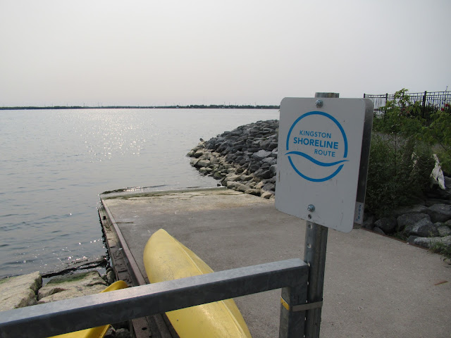
A recent stroll around the Lower Union Street dock and the former Kingston Shipyards site reminded me of some earlier views. Vestiges of the marine railway exist (below), with this concrete boat ramp lined with rails still, and a yard-long piece of rail among the rocks in the water. The wooden minesweeper HMCS Resolute is launched (top photo) on June 20, 1953 with a tugboat standing by. (Queen's University Archives, George Lilley fonds, V25.5-31-25-1)
Private yacht Sirocco is launched on May 14, 1959 (below) with invited guests on a platform spanning the marine railway. Another vessel or scow visible at the shipyards at left (Queen's University Archives, George Lilley fonds, V25.5-25-55)
Part of the Shoreline Route waterfront trail now, the modern-day trail-walkers likely have no idea there was a large shipyard building outside which these vessels took shape before launching down the ways. Vessels larger than kayaks! There is little interpretation at the site. The city hopes to make this a deepwater dock to lure cruise-ship traffic. (Get going on it now, while there are no cruise-ships travelling the Lakes!)
A reverse view, from the shipyards launchways over to the marine railway. Large timbers and pipes still line the shoreline where corvettes and other vessels entered the lake:
Lyall Scott Dougan's pilot house pre-dated the parkland here, shown in the early-1970's along with signage for the City water intake suction pipe (below). The advent of the Seaway meant that the shipping channel was on the American side of the St. Lawrence; few ships in the immediate area needing pilotage.
One more view from the marine railway, showing the former Marine Museum of the Great Lakes at background left, the ever-present skyline-sucking condos and the launchways remnants:
The corvette HMCS Napanee was launched at the same location on August 31, 1940. A capacity crowd lined the waterfront for the occasion (Queen's University Archives, George Lilley fonds, V25.5-45-43).
I was able to do a picture-in-picture representation of the RCMP's Fort Resolute being built at the Shipyards in July 1958, overlaid with the current apartments:

Saturday, 12 September 2020

Putting out an A.P.B. (Archives Photo Bulletin!)


Perusing the above list, it's a checklist of things people don't photograph. Places that are so ubiquitous and commonplace that no-one thinks to snap a photo. They'll always be there! 

If I had to create a list of what is not to be found in the Queen's University Archives, my list would largely overlap their published list, above. Trying to find more than an occasional, documentary view of Kingston's waterfront industries is indeed....trying. The Canadian Locomotive Co. is an exception - fortunately its archives are preserved in Kingston and in Ottawa. Besides that, there are lots of limestone houses and family photographic pedigrees. But what did people do all day for their livelihoods? 

Businesses changed hands frequently. So one photo does not preserve all! Basic streetscapes tell us so much as a given snapshot in time - buildings, vehicles, people, the times in both economic and social terms.

So I'll do my part to dig, delve and document that which the Archives has had trouble finding!


Wednesday, 2 September 2020

Presland Iron & Steel on Maple Street

A drive down maple Street netted me this discrete but well-designed logo that I can use on my Hanley Spur layout (top photo). Presland is built onto the former Gould Storage Battery building between Maple Street and John Counter Boulevard (formerly Elliott Avenue). The travelling crane was moving a few small pieces around:
It's a tangled web in the trees back here. The remnants of Frontenac Floor and Wall Tile are near here, as are a few houses and a body shop. 
At the north end of the travelling crane, we can see the north side of the former Gould building:
The south end of the travelling crane shows the photogenic south side of the former Gould building, often photographed!
Here's that southern exposure from the west side. Check out those interesting oval-top windows! And the retro signage! Well, it wasn't retro in August, 1950. (Queen's University Archives, George Lilley Fonds, V25.5-13-49)
A chequered history. The building's prior owners, from Kingston Insurance maps and other sources:
  • Reliance Moulding, 1914 (manufacturing among other things, signal flag poles in WWI)
  • Dominion Webbing, 1933
  • Presland owned by Preston family since 1970
The east end of the south side. The metal-clad building is where the Presland covered travelling crane now operates. Taken during a strike at Frontenac Floor and Wall Tile in March, 1952. (Queen's University Archives, George Lilley Fonds, V25.5-18-43)

This January, 1948 aerial view shows my route: east along Counter, south on Maple, then east, and eventually to Cassidy Street. Today there is little remaining evidence of Frontenac Floor and Wall Tile's presence (bottom left). (Queen's University Archives, George Lilley Fonds, V25.6-1-14)